Every year, Tori and I enjoy a small getaway to celebrate our wedding anniversary. Normally, we go somewhere different each trip but because of COVID-19 we decided to return to Tucson for our 7th Anniversary. With the plethora of outdoor activities in the surrounding nature parks, we knew we could stay socially distanced and not feel like we missed out on all the city could offer since we visited last year before the pandemic. On Tuesday, we took the six hour drive to Arizona and arrived at the Hotel Tucson City Center by 4pm. It had been lightly raining during the drive but the setting sun broke though the clouds and illuminated the city soon after we checked in. Located in the Presidio district, we had a great view of Downtown from our balcony a few blocks away.
After unpacking, we drove out to the Tucson Mountain Park to watch the sunset at the Gates Pass Overlook. We had visited this spot last year during the daytime and I promised myself that we would return during a sunset. We hiked up the short distance to one of the two stone huts built by the Civilian Conservation Corps (CCC) in the 1930's during the Great Depression. Though defaced with graffiti on the inside, it sits perfectly perched at the steep edge of the mountain pass with wonderful views of the park and Old Tucson in the distance. At first, I thought we missed the golden hour as the sun had disappeared behind a bank of clouds and covered the mountains in a gloomy shadow. My worries quickly dissipated as the sun reappeared and illuminated the pass in magical warm glow that was as spectacular as I had hoped. After the sun fell below the horizon, we returned to the hotel and ordered takeout dinner from El Charro. I had the same delicious Carne Seca Chimichanga as last year while Tori tried the Enchiladas.
It was supposed to be rainy on Wednesday but we woke up to beautiful sunny skies. Our plan was to go to breakfast in the Barrio Viejo District and then explore the Historic Adobes in the old neighborhood. At 8:30, we walked into Downtown and checked out the St. Augustine Cathedral along the way. The double-spired cathedral is the mother church of the Roman Catholic Diocese of Tucson and was first built in 1866 to replace the original chapel. It was rebuilt in 1897 and again in 1928 where it took its current Mexican Baroque form. A 1968 restoration kept the towers and the façade but replaced everything else.
Our first stop in Barrio Viejo was The Coronet. It was quiet on a Wednesday morning so we had the outdoor patio to ourselves in the warm sunshine. Tori ordered the Lil Dutch Babies and I had the Buttery Biscuits and Gravy. Both were very tasty! As we sipped our cappuccinos, we received the notification on our phones that President Biden had officially taken the Oath of Office on the steps of the Capitol that had been overrun two weeks earlier by domestic terrorists trying to overthrow the election results. Crazy Times!
Across the street from the French café was the Teatro Carmen, built in 1914 while the Mexican Revolution was in full swing below the Arizona border. Founded by Carmen Soto Vasquez, the 1,400 seat adobe theatre, built in the Sonoran-mission style, was devoted exclusively to dramatic works in Spanish. By 1922, it was transformed into a movie theater, dance hall and boxing arena that last until 1926. Over the years, the copper-colored building has served as a garage and an Elks Lodge. Its exterior has served as a backdrop in several movies, including Drew Barrymore's "Boys on the Side" in 1995.
Circling the block, we came to the El Tiradito Wishing Shrine, a catholic shrine inside an outdoor grotto where visitors leave offerings, light candles and write their wishes on slips of paper they tuck into the gaps of the adobe brick wall. Instead of a saint, the shrine is dedicated to El Tiradito (The Little Castaway), a sinner who could not be buried in consecrated ground. According to the legend, a young ranch hand, Juan Oliveras, married the daughter of a powerful sheep rancher in the late 1800's but Juan fell in love with the rancher's wife and began an affair. When the rancher, Francis Goodwyn, caught the two lovers in his own bed, he chased Juan into the street and killed him with an axe. After Francis fled to Mexico to escape the murder charge, he was scalped, stabbed and shot by a raiding band of Apaches after he returned to Tucson. The shrine was first built over the grave of Juan Oliveras who was buried where he fell. The local saying goes that if your candle stays lit through the night, your wish will come true.
After visiting the shrine, we ventured deeper into Barrio Viejo that mainly consists of historic homes and commercial buildings made of adobe bricks in the late 1800's when the Southern Pacific Railroad was built to pass through the area after Tucson was added to the United States from Mexico in the Gadsden Purchase of 1854. A large section was bulldozed in the 1960's and 1970's for urban redevelopment and the Tucson Convention Center but a concerted effort has been made to conserve the rest. Now this large collection of colorful adobes of this old neighborhood is one of the more desirable places to work and live in the city.
Walking South on Convent Avenue, we passed the Parque de Orlando y Diego Mendoza with a small shrine dedicated to the two children who were killed by a drunk driver in 1981. We turned East along 21st Avenue before walking back North by way of 7th Avenue. Walking through the colorful neighborhood, we had a great view of Sentinel Peak and Tumamoc Hill rising in the background. We had a nice chat with a local man walking his dogs as we passed the Pio Decimo Garden. At the 5 Points Intersection we could see the five new arches nearing completion bearing the names of the four surrounding neighborhoods: Barrio Viejo, Barrio Santa Rosa, Barrio Santa Rita and Armory Park.
Heading north on Stone Avenue, we passed the Jewish History Museum before finishing our Barrio Viejo walk at the San Carlos Apartments across 6th Avenue from Armory Park where we practiced our AcroYoga with the local community during our trip last January. Going back through the city, we stopped at Johnny Gibson's Downtown for some sandwiches to take with us to the Chiricahua National Monument the next day. We had walked almost 5 miles by the time we returned to our hotel at noon where we spent the next couple hours relaxing and watching the Presidential Inauguration.
Our original plan for Wednesday afternoon was to visit Sabino Canyon and ride the tram up into the Santa Catalina Mountains, but due to the forecasted rain, the parking lot and trams were closed by the forest service. Instead, we drove over to the University of Arizona at 2pm to walk around. It was pretty quiet, but there were still students hanging out on the grassy mall running down the center of the red-bricked campus. The university was founded in 1885, the first in the Arizona territory and built on land donated by two gamblers and a saloon keeper. The Old Main building was completed in 1891 and taught 32 students their first year. The gathering clouds were threatening to rain on us, but the grey skies only released a few droplets as we circled Arizona Stadium. Outside the West Entrance to the campus, we stopped for beer and a snack at the Frog & Firkin. Their deep dish pizza looked really good so we shared a slice of their Falcon Firkin, topped with grilled chicken, blue cheese crumbles, jalapeños and a drizzle of wing sauce. Tasty!
After relaxing at the hotel for a few hours, we decided to walk over to the Historic Forth Avenue for dinner. The quickest route, ended up being the wrong route as we had to pick our way through all the road construction during our mile walk to the shopping district. At Boca Tacos y Tequila, we were seated in the outdoor patio under a warm heat lamp and ordered the Paloma Margaritas. (Update: The owner competed on Top Chef Season 18) While Tori had the Pescado and Camaron Tacos, I tried the Taco Dog and the delicious Caramelo quesadilla. We also shared a couple Boca Balls (Chipotle mashed potatoes, breaded and fried). For dessert, we stopped at the Dairy Queen on our walk back for a Blizzard. By the time returned to our room, we had walked over 10 miles on our first full day.
After an early breakfast on Thursday at the hotel, we drove two hours to reach the Chiricahua National Monument (Pronounced "Cheer" - "i" - "cow" - "ah") near the border between Arizona and New Mexico. We had our fingers crossed for sunny weather at our destination as we drove through Cochise County in a light rain. On Highway 186, we passed through the foothills of the Dos Cabezas Mountains where we could see the distinctive double peaks that inspired their name. It was still sprinkling as we reached the Chiricahua visitor center at 10am.
After picking up a hiking map, we drove up Bonita Canyon Drive, an eight mile scenic road that winds through the canyon and is lined with towering rock pinnacles. These mountains were the home of the Chiricahua Apaches until they were relocated to reservations in Oklahoma and New Mexico after their battles with the U.S. Army. They were taken away after Geronimo surrendered in 1886 and were the last Native American tribe to be moved. We parked at the Echo Canyon Trailhead where we had a great view of Sugarloaf Mountain. The rounded peak is 7,310 feet tall and has a 1.8 mile roundtrip trail from the nearby parking lot off Bonita Canyon Drive.
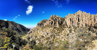
It was still chilly but the rain had stopped and the sun was coming out as we started our mountain hike on the Echo Canyon Tail. Descending counter-clockwise on the four mile loop trail, we passed through the awe-inspiring Echo Canyon filled with hoodoos, tall pinnacles and balancing rocks. Neon green lichen covered the rocky surfaces, shining brightly after the morning rain. A half mile down the canyon, we found the Grottoes where the trail winds through a cluster of tightly packed formations.
Called “Standing Up Rocks” by the Apaches, the rock pinnacles in this sky island originated when the Turkey Creek Volcano spewed ash over the area 27 million years ago. The ash hardened into layers of grey rock called Rhyolite. Over millions of years, the mountains lifted and eroded away at the joints and cracks until the slopes were covered in endless spires and balancing rocks.
Further down the canyon, we passed under the shadows of Wall Street. The Civilian Conservation Corps carved out this 40 foot long corridor during the Great Depression when they built 17 miles of trails through this national monument. Leaving the rocky ground behind, we entered a pine-filled valley called Echo Park where fallen trees from an earlier forest fire were steaming in the sun after the morning rain. We could see the water vapor rising off the burnt tree trunks.
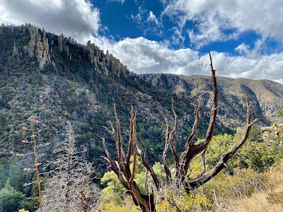
Near the bottom of Echo Canyon, the route turned east to follow Hailstone Trail up the larger Rhyolite Canyon. This straighter trail had expansive views of the wide canyon with clouds racing between the tall pinnacle formations lining the rim on both sides. This park sits on a Sky Island, an isolated mountain range that rises up from the surrounding desert sea. It sits at the crossroads of 4 major ecosystems, the Rocky Mountains, Sierra Madre, Sonoran Desert and Chihuahuan Desert.
The South-Facing slopes in this sky island are warmer and dryer and have a different ecosystem than the cooler North-Facing slopes where the Ponderosa Pine and Douglas-fir need more water to grow. Two-thirds of the way up the canyon, we encountered a textured rock formation on Hailstone Trail. I am guessing this pebbly surface in the picture above is the reason for the trail’s name.
Leaving the Hailstone behind, we turned and completed our hike on the Ed Riggs Trail. The final part of the loop trail is named for a local rancher who helped convince the government to protect the area as a National Monument. He also acted as the Trail Foreman who designed and built the trails while employed by the CCC. Hiking up the trail, we actually passed a small group of current CCC workers repairing a washed-out section. The Echo Canyon Loop Trail is now one of my favorite hikes.
After our hike we drove to Massai Point at the top of Bonita Canyon Drive for the panoramic views of the pinnacle-lined canyons below while the clouds thickened and the sky grew grey. We were starving, so our sandwiches tasted extra good while we sat on our tailgate and enjoyed the view. A few Mexican Jays gathered, staring greedily at our lunch. The next stop of our day trip was historic Tombstone that was an hour and a half away. As we drove south through the ranch lands, we were caught in a heavy downpour while passing along the edge of dramatic storm clouds, but we left them behind as we turned west. The ridgeline of mountains were painted pink in the sun as we reached the outskirts of the former mining town.
We walked the wooden boardwalks of Allen Street before boarding a horse-drawn stagecoach. The driver told us the history of Tombstone that grew rapidly after a silver vein was discovered in 1877. The Earp brothers started arriving at the end of 1879 to capitalize on the booming growth as numerous saloons, gambling halls, theaters, dance halls and brothels sprung up to service the miners. Conflict grew between the Democrat ranchers who had supported the Confederacy and the mostly Republican miners and businessman from the North. This resulted in the famous gunfight near the O.K. Corral on March 15, 1881 between Wyatt Earp, Doc Holliday and the outlaw Cowboys who made their living smuggling alcohol, tobacco and cattle across the nearby border with Mexico.
It is estimated that 1,000 metric tons of silver were mined before they delved too deep under the water line. When the hoist and pumping station burned in May 1886, the depleted mines flooded and were mostly abandoned as the town shrunk. After our stagecoach ride, we completed our walk, passing saloons full of cowboys dressed in period gear. I wanted to stop for a couple beers, but I still needed to make the long drive back to Tucson. We settled for pieces of fudge from the Fallen Angel sweet shop instead. After we returned to our hotel in Tucson, we walked over to Ermano’s Wine Bar that we visited last year as well. Downtown was more deserted this year with lots of former restaurants closed. It had rained all day in Tucson while we were gone so it turned out to be perfect timing for our day trip.
After the private Space Biosphere Ventures dissolved, Columbia University took over managing BioSphere 2 until 2003. To save it from demolition, the University of Arizona took over management in 2007 and finally purchased the complex in 2011. Instead of testing a closed ecosystem for future space exploration, both of the universities have used the facility as a massive laboratory to study our own planet with earth science experiments. Our first sight on the audio walking tour was the stepped pyramid enclosing the Tropical Rainforest biome. Walking along the outside of the giant steel and glass structure, we could see the heavy vegetation pressing right up against the clear glass. Due to the pandemic, I had been expecting that we would only be walking around the outside so I was surprised when the tour led us through the airlock of the Human Habitat. While we did not enter the former living quarters, we could see inside the Quonset hut shaped domes that had been used for growing food by the BioSpherians. This former agricultural space has now been repurposed into the Landscape Evolution Observatory (LEO) where three giant sloped platforms that weigh and measure every step of the process with 1,800 sensors as dead volcanic rock slowly transforms over many years into living soil that supports microbes and plants.
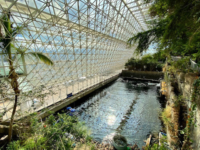
Leaving the Human Habitat side of BioSphere 2, we passed outside through the small Orchard that supplied the BioSpherians with fruit and even a small amount of coffee. Circling the outside of the complex, we saw the separate Energy Center that supplies power with two large generators. On either side of the sealed biosphere are the Lungs, two geodesic domes that regulated the air pressure by allowing the volume of air to expand during the hot days and contract during the cool nights with giant diaphragms. My favorite part of the tour came in the second half when we entered the other stepped pyramid that contained the Fog Desert biome. On our route through the interior, we passed through the Mangrove Wetlands and Savanah Grassland while looking down into the 700,000-gallon Ocean tank that contains a coral reef that Columbia University used to study the effect of climate change on our oceans. Our last stop was inside the Tropical Rainforest biome that we had seen from the outside at the beginning of our tour. The trees grew all the way to the ceiling of the 91 foot tall pyramid. It was an great tour and I would recommend it to everyone. It felt like we were exploring the lair of a James Bond villain.
After our tour of BioSphere 2, we stopped at the Catalina State Park on the drive back to Tucson. Since we were planning a tough hike at Picacho Peak the next day, we only walked to the nearby Romero Ruins and hiked the one mile Nature Trail loop. It was cool to examine the archeological remains of the prehistoric walled village of the Hohokam on this spot below the Santa Catalina Mountains. The five foot high protective walls were built around 1150 AD when the native tribes of the area started living in more defensible locations. The village was abandoned sometime between 1300-1450 AD. There are also building remains of the first Mexican rancher, Francisco Romero, who settled in the area in the 1800s and had to fight off frequent Apache raids. Archeologists think that Romero used cobbles from the earlier walls for his ranch buildings. During our hike, we noticed that the Cholla cactuses were drooping and the Prickly Pears along the trail were extremely thin and desiccated due to the drought conditions. The Saguaro and a Fishhook Barrel Cactus were the only ones who looked fairly normal.
After relaxing in our room for a few hours, we walked into Downtown for our 7th Anniversary Dinner at Charro Steak & Del Rey. It used to be a separate Mexican Steakhouse and Fish Restaurant but they combined their menus since we were in Tucson last year. After margaritas, I ordered the Tucson's T-Bone garnished with chili peppers while Tori had the Chile Con Queso Mini Chimis and the Ahi Ceviche. Everything was very tasty and we also enjoyed the Chile Verde Mashed Potatoes on the side. The restaurant treated us to an Anniversary Flan for dessert.
We woke up early on Saturday morning and saw the sunrise from our balcony before going to Barista Del Barrio for Horchata Lattes and Breakfast Burritos. We also bought some Marzipan Cupcakes and Barrio Strudel for an evening snack later. We packed and checked out of the hotel early so we could stop at Picacho Peak State Park on our drive home to San Diego. When we arrived, the rangers told us that the steep Hunter Trail to the peak was too full. We probably should have come on a less crowded week day. Instead of waiting until after 1pm for the chance the trail would reopen, we decided to leave since we had a 6 hour drive ahead of us. It was snowing as we passed through the mountains and we stopped for dinner at Raising Cane's in Santee. It had a huge line, but it was worth the wait to try their tasty chicken fingers for the first time.


